✨ New Arrivals Just Dropped!Explore

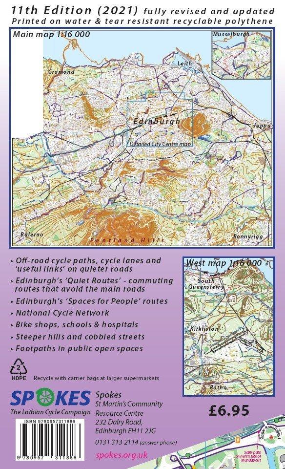
Edinburgh Cycle Map - 11th Edition, 2021
The new Edinburgh Cycle Map (11th edition), produced by Spokes (the Lothian Cycle Campaign), is here! Fully revised and updated, the map shows new cycle infrastructure and other developments across the city.
- Invaluable for cyclists and walkers seeking safe routes to shops, work or school and for planning leisure and running routes
- The whole city was surveyed by local Spokes volunteers and the mapping revised and updated by a skilled volunteer cartographer
- Major updates and improvements to the map include all the new housing developments across Edinburgh and contours and hill-shading so users can see the hill spots at a glance
- In addition, the back of the map now shows the area from South Queensferry to Newbridge, as well as the usual large scale map of the city centre
- With a scale of roughly 1:16,000 the map is great for walking as well as cycling. Smaller scale maps on the reverse help you plan bike or bike/rail trips further afield
- The maps are printed on tear and water-resistant synthetic paper which is fully recyclable
Features:
- 11th edition originally published in 2016, updated in 2021
- 1:16,000 the map is great for walking as well as cycling
- Emphasis on traffic-free cycle paths
- Printed on tear and water resistant paper
- Shows all the National Cycle Network routes
- Advises on quieter routes
- Profits go to the Spokes Lothian Cycle Campaign.
$10.21
Edinburgh Cycle Map - 11th Edition, 2021—
$10.21
More Images
Edinburgh Cycle Map - 11th Edition, 2021
The new Edinburgh Cycle Map (11th edition), produced by Spokes (the Lothian Cycle Campaign), is here! Fully revised and updated, the map shows new cycle infrastructure and other developments across the city.
- Invaluable for cyclists and walkers seeking safe routes to shops, work or school and for planning leisure and running routes
- The whole city was surveyed by local Spokes volunteers and the mapping revised and updated by a skilled volunteer cartographer
- Major updates and improvements to the map include all the new housing developments across Edinburgh and contours and hill-shading so users can see the hill spots at a glance
- In addition, the back of the map now shows the area from South Queensferry to Newbridge, as well as the usual large scale map of the city centre
- With a scale of roughly 1:16,000 the map is great for walking as well as cycling. Smaller scale maps on the reverse help you plan bike or bike/rail trips further afield
- The maps are printed on tear and water-resistant synthetic paper which is fully recyclable
Features:
- 11th edition originally published in 2016, updated in 2021
- 1:16,000 the map is great for walking as well as cycling
- Emphasis on traffic-free cycle paths
- Printed on tear and water resistant paper
- Shows all the National Cycle Network routes
- Advises on quieter routes
- Profits go to the Spokes Lothian Cycle Campaign.
Product Information
Product Information
Shipping & Returns
Shipping & Returns
Description
The new Edinburgh Cycle Map (11th edition), produced by Spokes (the Lothian Cycle Campaign), is here! Fully revised and updated, the map shows new cycle infrastructure and other developments across the city.
- Invaluable for cyclists and walkers seeking safe routes to shops, work or school and for planning leisure and running routes
- The whole city was surveyed by local Spokes volunteers and the mapping revised and updated by a skilled volunteer cartographer
- Major updates and improvements to the map include all the new housing developments across Edinburgh and contours and hill-shading so users can see the hill spots at a glance
- In addition, the back of the map now shows the area from South Queensferry to Newbridge, as well as the usual large scale map of the city centre
- With a scale of roughly 1:16,000 the map is great for walking as well as cycling. Smaller scale maps on the reverse help you plan bike or bike/rail trips further afield
- The maps are printed on tear and water-resistant synthetic paper which is fully recyclable
Features:
- 11th edition originally published in 2016, updated in 2021
- 1:16,000 the map is great for walking as well as cycling
- Emphasis on traffic-free cycle paths
- Printed on tear and water resistant paper
- Shows all the National Cycle Network routes
- Advises on quieter routes
- Profits go to the Spokes Lothian Cycle Campaign.