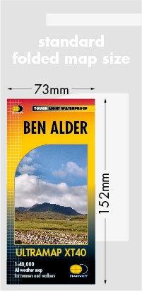
Ultramap Ben Alder - 1:40,000
A perfect size for your trouser pocket but still covering a large area. The Ben Alder map is a detailed map for runners and walkers exploring the area around Ben Alder west of Dalwhinnie and the A9. Includes Creag Meaghaidh and Corrour Station as well as 23 Munros, 4 Corbetts and 3 Grahams.
- Scale: 1:40,000
- Ratio: 2.5cm = 1km
- Flat Size: 876 x 304mm
- Folded Size: 73 x 152mm
- Weight: 25g
- Area of mapping: 718sqkm
- Double sided: yes
- Tough and 100% waterproof
Original: $16.27
-65%$16.27
$5.69Ultramap Ben Alder - 1:40,000
A perfect size for your trouser pocket but still covering a large area. The Ben Alder map is a detailed map for runners and walkers exploring the area around Ben Alder west of Dalwhinnie and the A9. Includes Creag Meaghaidh and Corrour Station as well as 23 Munros, 4 Corbetts and 3 Grahams.
- Scale: 1:40,000
- Ratio: 2.5cm = 1km
- Flat Size: 876 x 304mm
- Folded Size: 73 x 152mm
- Weight: 25g
- Area of mapping: 718sqkm
- Double sided: yes
- Tough and 100% waterproof
Product Information
Product Information
Shipping & Returns
Shipping & Returns
Description
A perfect size for your trouser pocket but still covering a large area. The Ben Alder map is a detailed map for runners and walkers exploring the area around Ben Alder west of Dalwhinnie and the A9. Includes Creag Meaghaidh and Corrour Station as well as 23 Munros, 4 Corbetts and 3 Grahams.
- Scale: 1:40,000
- Ratio: 2.5cm = 1km
- Flat Size: 876 x 304mm
- Folded Size: 73 x 152mm
- Weight: 25g
- Area of mapping: 718sqkm
- Double sided: yes
- Tough and 100% waterproof