Assynt Coigach British Mountain Map
"This is a fabulous map for a fabulous area; for the first time it shows crags, bouldering areas and clear details in what could seem a maze of rock and water. It must surely set the standard for all future maps." John Mackenzie, the Earl of Cromartie.
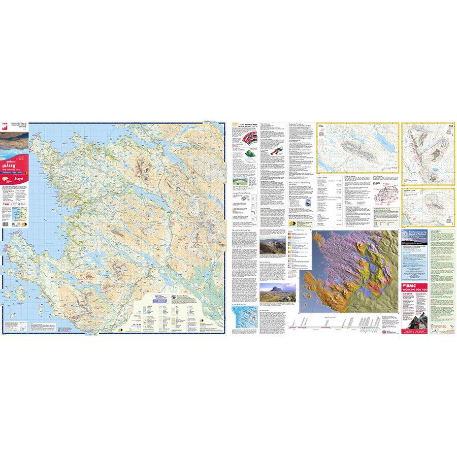
Detailed map for hillwalkers and climbers of the spectacular peaks of Assynt at 1:40,000 scale.
Includes Quinag, Suilven, Stac Pollaidh, Cul Mor and Ben More Assynt.
Enlargements at 1:15,000 scale of Stac Pollaidh, Suilven and Quinag on the reverse.
Climbing crags are highlighted and a climbing route on Stac Pollaidh is included.
The map area includes 2 Munros, 9 Corbetts and 6 Grahams.
- Tough, light, durable and 100% waterproof
- Genuine original HARVEY mapping
- Tried and tested by the British Mountaineering Council and the Mountaineering Council of Scotland
- Scale: 1:40,000
- Ratio: 2.5cm = 1km
- Flat size: 992 x 940mm
- Folded size: 124 x 235mm
- Weight: 90gms
- Area of mapping: 1228sqkm
- Double sided: yes
More Images

Assynt Coigach British Mountain Map
"This is a fabulous map for a fabulous area; for the first time it shows crags, bouldering areas and clear details in what could seem a maze of rock and water. It must surely set the standard for all future maps." John Mackenzie, the Earl of Cromartie.
Detailed map for hillwalkers and climbers of the spectacular peaks of Assynt at 1:40,000 scale.
Includes Quinag, Suilven, Stac Pollaidh, Cul Mor and Ben More Assynt.
Enlargements at 1:15,000 scale of Stac Pollaidh, Suilven and Quinag on the reverse.
Climbing crags are highlighted and a climbing route on Stac Pollaidh is included.
The map area includes 2 Munros, 9 Corbetts and 6 Grahams.
- Tough, light, durable and 100% waterproof
- Genuine original HARVEY mapping
- Tried and tested by the British Mountaineering Council and the Mountaineering Council of Scotland
- Scale: 1:40,000
- Ratio: 2.5cm = 1km
- Flat size: 992 x 940mm
- Folded size: 124 x 235mm
- Weight: 90gms
- Area of mapping: 1228sqkm
- Double sided: yes
Product Information
Product Information
Shipping & Returns
Shipping & Returns
Description
"This is a fabulous map for a fabulous area; for the first time it shows crags, bouldering areas and clear details in what could seem a maze of rock and water. It must surely set the standard for all future maps." John Mackenzie, the Earl of Cromartie.
Detailed map for hillwalkers and climbers of the spectacular peaks of Assynt at 1:40,000 scale.
Includes Quinag, Suilven, Stac Pollaidh, Cul Mor and Ben More Assynt.
Enlargements at 1:15,000 scale of Stac Pollaidh, Suilven and Quinag on the reverse.
Climbing crags are highlighted and a climbing route on Stac Pollaidh is included.
The map area includes 2 Munros, 9 Corbetts and 6 Grahams.
- Tough, light, durable and 100% waterproof
- Genuine original HARVEY mapping
- Tried and tested by the British Mountaineering Council and the Mountaineering Council of Scotland
- Scale: 1:40,000
- Ratio: 2.5cm = 1km
- Flat size: 992 x 940mm
- Folded size: 124 x 235mm
- Weight: 90gms
- Area of mapping: 1228sqkm
- Double sided: yes