✨ New Arrivals Just Dropped!Explore
Superwalker Ben Nevis Map
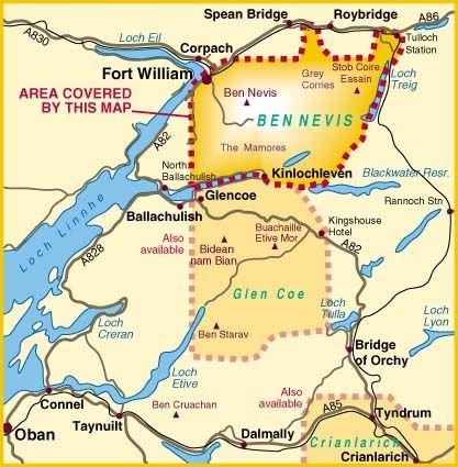
Harvey's Ben Nevis Map gives detailed information for climbers and hill-walkers. This map covers areas from Fort William through to Glen Nevis to Loch Treig. From the Grey Corries south to Kinlochleven. Ben Nevis, the Aonachs and the Mamores are among the 20 Munros and 4 Corbetts.
Clear and easy to read with all the detail needed for ascending Britain's highest mountain. Enlargement of Ben Nevis summit showing the safety bearings in case of a descent in bad weather.
Scale - 1:25,000.
- HARVEY Superwalker map at 1:25,000 scale
- Bio-degradable map
$21.72
Superwalker Ben Nevis Map—
$21.72
Superwalker Ben Nevis Map
Harvey's Ben Nevis Map gives detailed information for climbers and hill-walkers. This map covers areas from Fort William through to Glen Nevis to Loch Treig. From the Grey Corries south to Kinlochleven. Ben Nevis, the Aonachs and the Mamores are among the 20 Munros and 4 Corbetts.
Clear and easy to read with all the detail needed for ascending Britain's highest mountain. Enlargement of Ben Nevis summit showing the safety bearings in case of a descent in bad weather.
Scale - 1:25,000.
- HARVEY Superwalker map at 1:25,000 scale
- Bio-degradable map
Product Information
Product Information
Shipping & Returns
Shipping & Returns
Description
Harvey's Ben Nevis Map gives detailed information for climbers and hill-walkers. This map covers areas from Fort William through to Glen Nevis to Loch Treig. From the Grey Corries south to Kinlochleven. Ben Nevis, the Aonachs and the Mamores are among the 20 Munros and 4 Corbetts.
Clear and easy to read with all the detail needed for ascending Britain's highest mountain. Enlargement of Ben Nevis summit showing the safety bearings in case of a descent in bad weather.
Scale - 1:25,000.
- HARVEY Superwalker map at 1:25,000 scale
- Bio-degradable map