✨ New Arrivals Just Dropped!Explore

Skye Trail
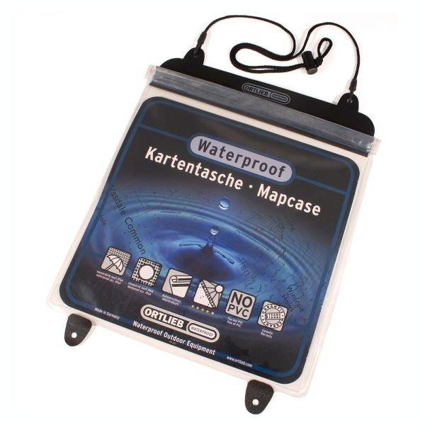
The Skye Trail is a challenging unofficial route through the island which is specifically aimed at experienced hillwalkers. The route follows much of the amazing Trotternish Ridge and passes beneath the peaks and pinnacles of the Cuillin, which are considered to be the finest mountains in Britain. There are also remarkable coastal cliffs, steep trails, high drops and haunting ruins of deserted villages destroyed in the highland clearances. You have various choices of different routes through tough terrain or easier walking with spectacular mountain views and coastal scenery. It is not waymarked making this map an essential piece of your equipment.
- XT40 New generation of tough polyethylene maps
- Now the advanced technology used in the creation of the best-selling British Mountain Maps is also applied to the route maps.
- These maps are a leap forward in technical excellence. They are tough, durable, light and 100% waterproof - virtually indestructible in normal use.
- They are light to carry, and compact - not the great bulky package you get with a laminated map.
- The map is detailed, with the routes clearly marked. It also contains general information, useful telephone numbers and a full key.
$22.47
Skye Trail—
$22.47
Skye Trail
The Skye Trail is a challenging unofficial route through the island which is specifically aimed at experienced hillwalkers. The route follows much of the amazing Trotternish Ridge and passes beneath the peaks and pinnacles of the Cuillin, which are considered to be the finest mountains in Britain. There are also remarkable coastal cliffs, steep trails, high drops and haunting ruins of deserted villages destroyed in the highland clearances. You have various choices of different routes through tough terrain or easier walking with spectacular mountain views and coastal scenery. It is not waymarked making this map an essential piece of your equipment.
- XT40 New generation of tough polyethylene maps
- Now the advanced technology used in the creation of the best-selling British Mountain Maps is also applied to the route maps.
- These maps are a leap forward in technical excellence. They are tough, durable, light and 100% waterproof - virtually indestructible in normal use.
- They are light to carry, and compact - not the great bulky package you get with a laminated map.
- The map is detailed, with the routes clearly marked. It also contains general information, useful telephone numbers and a full key.
Product Information
Product Information
Shipping & Returns
Shipping & Returns
Description
The Skye Trail is a challenging unofficial route through the island which is specifically aimed at experienced hillwalkers. The route follows much of the amazing Trotternish Ridge and passes beneath the peaks and pinnacles of the Cuillin, which are considered to be the finest mountains in Britain. There are also remarkable coastal cliffs, steep trails, high drops and haunting ruins of deserted villages destroyed in the highland clearances. You have various choices of different routes through tough terrain or easier walking with spectacular mountain views and coastal scenery. It is not waymarked making this map an essential piece of your equipment.
- XT40 New generation of tough polyethylene maps
- Now the advanced technology used in the creation of the best-selling British Mountain Maps is also applied to the route maps.
- These maps are a leap forward in technical excellence. They are tough, durable, light and 100% waterproof - virtually indestructible in normal use.
- They are light to carry, and compact - not the great bulky package you get with a laminated map.
- The map is detailed, with the routes clearly marked. It also contains general information, useful telephone numbers and a full key.